
Mapping of Shelter Cove for the
Resort Improvement District No.1
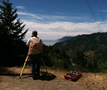
Control survey for aerial mapping of entire Shelter Cove Subdivision area managed by RID#1, including the generation of contours on 5 foot intervals. Target locations included remote areas such as Black Sands Beach, Paradise Ridge Road, and the Chemise Mountain Wilderness Area. Points West served as the liaison between 3Di West and RID#1 to ensure the final product met the District’s future needs.
The primary purpose of this mapping was to facilitate water planning, including possible reservoir sites, for future growth of the District. Specific tank sites and possible reservoir sites were mapped conventionally to gather data sufficient for future design. Property boundaries were determined on a number of District owned properties before additional water wells were drilled to supplement the water collection system. Ongoing work includes additional topographic surveying to support a possible fish ladder design or other alterations to the current intake system on Telegraph Creek.